This past Sunday I took my ATV (The Griz) to Ouray, Colorado. Ouray is rich in mining history and I have long wanted to explore the Jeep trails in the area. In addition to the photos in the narrative I have included a photo gallery at the end of this post. As usual, clicking on an image will open a larger version.
There were three places I wanted to get to on this trip: Yankee Boy Basin, Governor Basin, and Imogene Pass. I had looked at my maps and planned to visit Yankee Boy Basin first then work my way back through Governor Basin and Imogene Pass. This would put me closest to the parking area at the end of my ride.
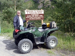
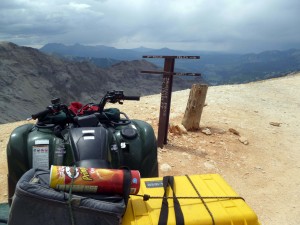
Note: Gear on The Griz included a grey soft cooler carrying beverages and lunch and a yellow camera case on the rear rack. My tripod (in a green sleeve,) baseball cap, and small carry-all bag are on the front rack. My helmet sits on the seat.
The day dawned bright and sunny but with a chance of afternoon showers. I unloaded The Griz and started up the road to Yankee Boy Basin. Due to mining activity that continues in this area, mostly for gold and silver, the lower part of the road is in good condition and can be traveled by passenger cars. It quickly becomes a shelf road, though, narrow and with little room to pass. Here is The Griz at a popular photo spot:
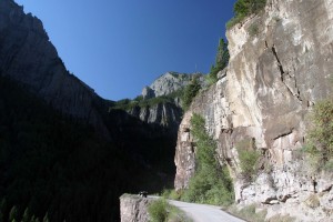
Not much further up the road you come to The Overhang where the road passes below a large rock outcrop.
Very shortly you start seeing remains of the large mines and ore milling operations that operated in the area. Most date from the 1870s into the early 1900s. Here and there a few bits and pieces of buildings and equipment remain. Much of this is on private land and cannot be approached for a closer view. Take a look at the photo gallery to see some of these remains.
I will say that wildflowers in the area were blooming in some profusion. I don’t know the names of these flowers near the Torpedo Eclipse Mill but they sure looked great!
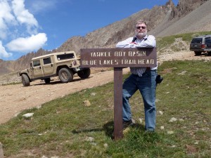
I worked my way up the valley and eventually arrived at the top of Yankee Boy Basin. From here a couple hiking trails take off including one that goes to the top of Mt. Sneffels, one of Colorado’s “fourteeners.” (Fourteeners are peaks that are over 14,000 feet in elevaton.)
Objective #1 for the day met, I backtracked down to the turn off to Governor Basin. Similar to Yankee Boy Basin, the Governor Basin area was rich in gold and silver deposits.
Old mine tailings dot the area. One mine had a modern bucket loader and compressor parked near the mine entrance and the entrance road was blocked by a locked gate, all indications the mine is currently being worked. The guide book I was using listed this mine, the Mountain Top Mine, as being open to visit but obviously things have changed in the last 2 years since publication. Not unusual given the rise in the price of gold. A couple other mines showed similar activity. Many of the claims in the area are privately held and periodically worked.
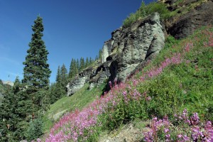
Wild flowers in this area, which is above timberline, were great. Although the sky was getting dark the flowers were still vibrant. Here is one of the meadow areas I passed.
With objective #2 met I headed back toward the turn-off for Imogene Pass. On the way down it started to rain lightly. By the time I made it to the turn for Imogene Pass it was raining moderately hard.
The road – more like a trail – to Imogene Pass was the roughest trail of the day. Later I found out why: The better road goes through a mining property and is often gated. The “alternate” road basically follows a power line easement. I came back on the better road as, on this weekend, the gates were open.
I stopped and put on my windbreaker in an attempt, mostly sucessful, to stay dry and continued up the trail. I counted on the rain stopping a bit later as that is the pattern of mountain storms, and eventually the rain did stop and the sun returned although filtered by a few remaining clouds.
I have to get back here again. There are numerous waterfalls along this route and I did not get to take them all in. (The route to Yankee Boy Basin also had waterfalls; you can see photos of them in the gallery.)
I made it to the top of the pass, looked around, and headed back down. It was getting late in the afternoon and I wanted to look over some mine ruins I had passed on the way up and find a place to eat a late lunch.
Although I was now drying out and had enjoyed myself a great deal, it was time to head back to the car and pack up up for the trip home. On the way back to the parking lot my phone buzzed indicating I was back in cell phone coverage. I had a call from Pam: Our land offer had been accepted! That was a great delight to hear.
I got back to the parking lot, loaded The Griz, and headed out for the 2.5 hour trip back to DeBeque. I was very tired when I arrived home even though I had only ridden about 40 miles total. With all my photo stops and lunch this back woods trip worked out to an average speed of 5 miles per hour. Much of the trip was done in low-range 4-wheel drive giving me about 15 miles-per-gallon fuel economy.
I really enjoyed this outing. The afternoon rain made for less than ideal photo opportunities and I would like to get back to shoot some better photos. There are other routes in the area to ride as well. I could spend several days here and not get to all the trails shown on the back country maps.
Although the area is remote it is popular for Jeep tour operators and off-road folks. I saw dozens of Jeeps, ATVs, UTVs (those are the side-by-side rigs that look like overgrown golf carts) mountain bikers, both pedal type and motorized variety, and hikers. Lots of help around in case of a breakdown or other problems. The roads were better than I expected except for Imogene Pass. High country trails, flowers, waterfalls, mining history…my kind of trip. It was a good day!
Normally I carry just my little point-and-shoot Panasonic camera. This time I carried an older Canon digital camera equipped with a mild zoom lens as well. It has been a while since I dealt with F-stops and shutter speeds, but I want to have more creative control over my photos and the Canon seems a good way to get there. There are photos from both cameras in the gallery. Although the Canon EOS 10d is rated at only 6.3 megapixels, low by today’s standards, for web photo use it should be OK.
That’s it for now. Thanks for looking in!




Resolution on the Canon was more than sufficient for the Internet — more would have taken far too long for the jpegs to resolve.
Beyond the rain, it looks like you had a nice day to travel. The aging of old mining buildings & equipment is always interesting — surprisingly large tailing mounds in at least one shot. Wonder what they’re pulling out of active mines — obviously good enough to make a few dollars at today’s prices.
Also noted the round-about driving route to get Ouray — added a bit of distance to your route, making it an even longer day.
3+ gallons used?
Larry:
Thanks for the note. Gas: 2.6 gallons used in The Griz. Camera: The Canon should do OK. The program I use requires files less than 2mb in size for web publishing, and the Canon produces files in about 1.1 – 1.2 mb, a good fit. Mines:
Millions (1880 dollars) taken out of this area, mostly gold and silver. Photo of the tailings is the Virginius Mine, discovered in 1876. it was worked into the 1980s and may again open. See article at http://www.watchnewspapers.com/pages/full_story/push?article-Revenue-Virginius+Poised+to+Apply+for+Mining+Permit%20&id=19063922
Thanks for the note!
i am so jealous of those wildflower views!!!
you take such cool trips–i can’t even imagine all the amazing pictures you have!