I was going to answer some of the comments in a reply, but the full answers are relatively long. I decided to do a post instead. (Note: Clicking on an image will bring up a larger and more legible version of that image.)
Tabitha:
We don’t know about wild horses in the Cripple Creek area. We currenlty live east of Wild Horse Mesa, where wild horses run in a protected area. I’ve gone 4-wheeling there but have not seen the herd. Every few of years some of the horses are trapped and sold at auction to keep the numbers sustainable. In the Cripple Creek area we are more likely to see deer and elk.
Larry:
I have an lot-map-plus-arial-view overlay provided by the county, but the overlay is wrong. It puts the lot to the east of the access road. It looks like the county flipped the overlay to the right instead of to the left, so I didn’t scan and post that document.
Yes, there is an acess road on the west side of the Martha A. We have walked it. There is an interesting reason it is there: The parcel to the south, the Last Chance, does not run all the way out to the BLM access road. While that owner has built a drive out to the road, it may not be legal. The access road on the west side of the Martha A is there to get legal access to the Last Chance if the BLM ever gets nasty about access.
Why the strange lot shapes and overlays?
Originally land in the Cripple Creek area was all government-owned. Miners could plat a claim then file for a “land patent” which transfered the land into their ownership. The overlapping occured when other parties moved in and platted lots that included parts of existing, but not patented, claims. The government could approve the new plat and make the claim available to patent. Often land between claims would be patented, hoping that any mineral veins from the other plats would extend into these lots. This practice lead to some very stange parcel shapes. (There were charges of claim jumping and other illegal actions dealing with the legitimacy of some land patents, and new court cases occasionally come up to this day.)
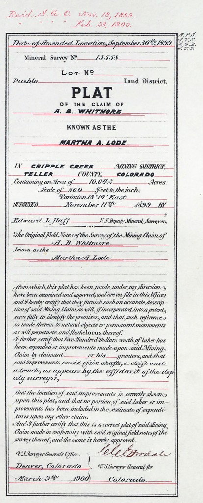
Here is part of the original 1899 Martha A plat I found in the BLM records:
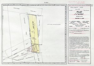
Note the phrase “…if incorporated into a patent…” in the document. At some point the Martha A was patented, moving the land from governement ownership into private hands. Below is the entire plat document.
“You don’t need a ROW for so-called “casual use.” What kinds of activities are considered “casual use”? Examples include driving vehicles over existing roads, sampling, surveying, marking routes, collecting data to prepare an application for a ROW, and performing certain activities that do not cause any appreciable disturbance or damage to the public land, resources or improvements.”
In other words, new road construction requires a ROW agreement. Use of existing roads does not, unless it is likely that use of those roads will damage them. At least thas is how I interpret it. The application sent to me (form DF-299) is geared toward new road constuction, such as might be used by mining or energy companies to reach and develope new sites.
If getting to a piece of unimproved land is “casual use” then we don’t need a permit. The existing road has been there for decades. We certainly will not be dististurbing or damaging public lands or roads. However, the lady I spoke to voiced the opinion that owning land moves the use of the road from “casual use” to “vested interest” and therefore requires a ROW permit. I’ve called the state office of the BLM to see if I can get some clarification on this.
1. If you have a “vested interest” and use the road to access it, the road needs to be covered by a Right of Way plan. If there is no agreement you are trespassing on BLM property when you use the road.
2. These plans are not normally issued to individual land owners, but can be in some cases. A road owner’s association generally needs to be formed to apply (and pay for) the road agreement.
3. The road association needs to register with the State of Colorado. ($35.00)
4. The county will not issue a building permit until the road agreement is in place.
There is a cost for all of this:
1. Impact statement processing fee: Average is category 3, $786.00. This fee covers up to 36 man-hours of labor. If it takes more than 36 man-hours the price goes up. Labor includes a site survey, vistit from foresters, hydrologists, and others to determin the impact of use on BLM land.
2. Rent of the portion of BLM land taken up by the road: $34.66 per acre per year for Teller County. Payable only in 10-year increments. After 30 years the agreement has to be re-negotiated.
3. Monitoring fee to make sure you are keeping the road up to standards set out in the agreement. It is about the same as the rent figure and can fluctuate.
4. Cost of bringing the road up to and maintaining standards set by BLM is born by who ever are named in the road agreement. (Generally this means grading the road once or twice a year and filling in potholes. Culverts must be cleaned and maintained as well.)
So what does this mean for us? It certainly raises a barrier, and is a catch-22: We may not be able to legally access the land without a ROW agreement (although the trespassing statutes are rarely enforced) and we can’t apply for an agreement until we own the land. Do we want to go down this path? Assuming we could get an individual agreement, it would mean an outlay of (non-refundable) funds to process the impact statement plus 10 years of rent and monitoring fees. Any work needed on that portion of the road would have to be done at our expense.
Now we know why the power and phone lines stop up the road. 🙂 Utilities require a separate agreement issued to the utility company. Can you say “off grid?”
This development certainly reduces the effective value of the lot. Legal access may not be completely secured, and there may be hoops to go though to finish the job. Ironicaly, we can drive the road as much as we wish while looking for land; that is casual use and quite legal. If we buy the Martha A and drive to it, we could be open to trespassing charges! Of course, we could always say we were gathering info to apply for a ROW agreement. Could take years. 🙂
I’m bummed out. Pam and I will have to talk this over, contact the realtor, and see if we want to proceed with an offer. I am still waiting on the response from the State BLM office before we go any further. I’ll post updates as I get them.


Leave a Reply